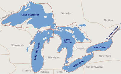
The Great Lakes are located in the northeastern section of North America, straddling the border or Canada and the United States. The 5 Great Lakes are Lake Superior, Lake Michigan, Lake Huron, Lake Eerie, and Lake Ontario. Measuring based on the surface area of their water, they form the largest group of freshwater lakes in the world, covering 244,106 square km - or 94,250 square miles. In fact, they hold 21% of the world`s fresh water on the surface.
A number of large cities and towns are located on the Great Lakes, the largest being Chicago which sits on the edge of Lake Michgan, as does Detroit. Toronto sits on Lake Ontario.
The Canada-USA border cuts through Lake Superior, Lake Huron, Lake Eerie, and Lake Ontario. Only Lake Michigan is situated entirely in the USA.
Here is a Great Lakes map that shows lots of detail.

This next map is actually a photo taken from a satellite, and is unlabelled.

Here is a labelled map of Great Lakes, also taken from a satellite.

This is map of Great Lakes area has all the information you would need.


.png)

0 Comments