Look down below to find a Nice France map to aid you in your travels
Nice is a city in the southeastern part of France, in the Provence region and in the vicinity of Italy and Monaco. It is the fifth largest city in France with a city population of 348,721 and a metropolitan population of around 955,000. It is thought to be one of the oldest places of human inhabitance in Europe.
The climate of Nice is, as you may expect, a typical Mediterranean climate with a long, warm, and dry summer that lasts as long as six months. The winters are wet and mild, certainly not beach weather most of the time, but pleasant and comfortable.
One of the most famous attractions in Nice is the Promenade des Anglais. The promenade was built by beggars who migrated to Nice to avoid a harsh winter up north. The English vacationers in Nice employed these beggars to build the promenade along the waterfront.
Here is a basic Nice, France map that you can print out

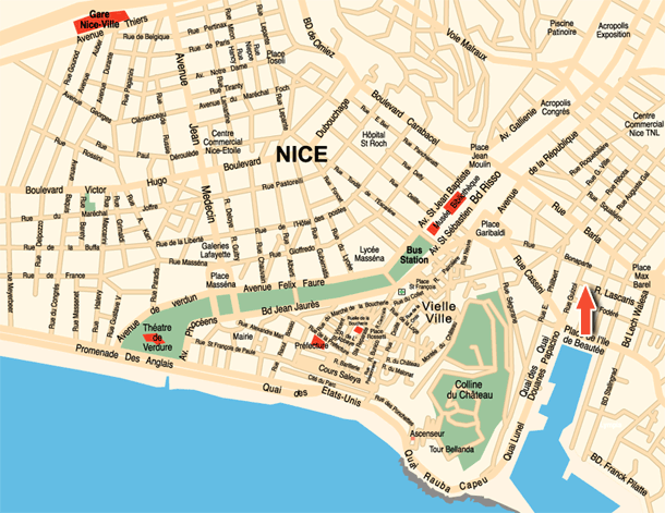
Here is a somewhat more detailed but useful map of Nice, France. It features some icons of famous landmarks that can help you find your way around the city.

Here`s another great, detailed Nice, France map to use for your reference and trip preparation. It doesn`t feature the useful icons of landmarks like the above map does, but this one is a little less cluttered because those icons obviously are not drawn to scale.

Hopefully you could find a good Nice, France map that you found useful. Be sure to check out our other map categories before you go!
Nice is a city in the southeastern part of France, in the Provence region and in the vicinity of Italy and Monaco. It is the fifth largest city in France with a city population of 348,721 and a metropolitan population of around 955,000. It is thought to be one of the oldest places of human inhabitance in Europe.
The climate of Nice is, as you may expect, a typical Mediterranean climate with a long, warm, and dry summer that lasts as long as six months. The winters are wet and mild, certainly not beach weather most of the time, but pleasant and comfortable.
One of the most famous attractions in Nice is the Promenade des Anglais. The promenade was built by beggars who migrated to Nice to avoid a harsh winter up north. The English vacationers in Nice employed these beggars to build the promenade along the waterfront.
Here is a basic Nice, France map that you can print out
Here is a somewhat more detailed but useful map of Nice, France. It features some icons of famous landmarks that can help you find your way around the city.

Here`s another great, detailed Nice, France map to use for your reference and trip preparation. It doesn`t feature the useful icons of landmarks like the above map does, but this one is a little less cluttered because those icons obviously are not drawn to scale.

Hopefully you could find a good Nice, France map that you found useful. Be sure to check out our other map categories before you go!


.png)

0 Comments