Down below you can find a Brittany France map for your reference
Brittany, France (or Bretagne as it is referred to in French) is a administrative region in the northwestern section of France. It is sometimes referred to as Lesser Britan or Little Britain, and is categorized as a Celtic nation. Brittany became a province of France in 1532.
Brittany is located on a big peninsula, with the English channel to the north, and the Bay of Biscay to the south. The population of the region is 4,365,000, with the largest city of Nantes having a metropolitan population of 711,120. The total land mass of the region is 34,023 km2.
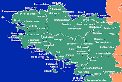
Here`s a detailed Brittany France map with all the towns and cities
This is a map of Brittany, France showing all the sub-regions

Here`s a Brittany, France map showing the roads and highways

Brittany, France (or Bretagne as it is referred to in French) is a administrative region in the northwestern section of France. It is sometimes referred to as Lesser Britan or Little Britain, and is categorized as a Celtic nation. Brittany became a province of France in 1532.
Brittany is located on a big peninsula, with the English channel to the north, and the Bay of Biscay to the south. The population of the region is 4,365,000, with the largest city of Nantes having a metropolitan population of 711,120. The total land mass of the region is 34,023 km2.
Here`s a detailed Brittany France map with all the towns and cities

This is a map of Brittany, France showing all the sub-regions

Here`s a Brittany, France map showing the roads and highways


.png)

0 Comments