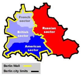
Below you can find a Berlin Wall map
At the end of World War II Berlin, the capital of Germany, was divided into four occupation zones, just as the entire country of Germany was. The Western countries` occupation zones (American, French, and British) were separated from the Russian occupation zone (East Berlin) by the Berlin Wall. The wall also encircled the Western section of the city to separate it from East Germany, making West Berlin a Western enclave inside East Germany. This meant that at times the only access to West Berlin was via the air.
The Berlin Wall was torn down in 1989 as the result of a non-violent revolution. Berlin and all of Germany were soon reunited afterwards.


Hopefully the above Berlin Wall maps were useful and informative. Have a look at our other map categories and be sure to bookmark or subscribe.


.png)


0 Comments