Philadelphia is one of those cities you may have never been to, but have definitely heard of from music, movies, and tv. It is a culturally important place, but not in the same way that some other major cities in the US are. That is partly because of Philadelphia`s proximity to New York City, by which it is often overshadowed.
The city has a population of over 1.5 million, and is the focal point of the Delaware Valley, a metro area with a total of over 6 million people. Philly is fifth largest city in America, and the metro area is also the fifth largest in the country. But the whole of the Northeastern United States is so densely populated that is almost like one giant megalopolis, incorporating both New York City whose metro area spreads over into Connecticut and New Jersey; Philadelphia whose metro area spreads from Pennsylvania into Delaware and New Jersey; Boston whose metro area spreads from Massachusetts into New Hampshire; Pittsburgh which is in Pennsylvania; Providence which spreads from Rhode Island into Massachusetts; Hartford in Connecticut; and Buffalo and Rochester in New York.
This first map of Philadelphia shows the city and its surrounding areas.

This next Philadelphia map shows the downtown area and its streets.

This last Philadelphia map is a good one for tourists, because it indicates important landmarks.
The city has a population of over 1.5 million, and is the focal point of the Delaware Valley, a metro area with a total of over 6 million people. Philly is fifth largest city in America, and the metro area is also the fifth largest in the country. But the whole of the Northeastern United States is so densely populated that is almost like one giant megalopolis, incorporating both New York City whose metro area spreads over into Connecticut and New Jersey; Philadelphia whose metro area spreads from Pennsylvania into Delaware and New Jersey; Boston whose metro area spreads from Massachusetts into New Hampshire; Pittsburgh which is in Pennsylvania; Providence which spreads from Rhode Island into Massachusetts; Hartford in Connecticut; and Buffalo and Rochester in New York.
This first map of Philadelphia shows the city and its surrounding areas.

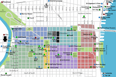
This next Philadelphia map shows the downtown area and its streets.

This last Philadelphia map is a good one for tourists, because it indicates important landmarks.


0 Comments