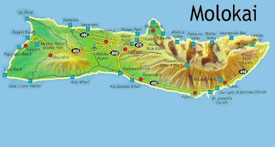
Find a good Molokai map down below
Molokai is a popular island in the Hawaiian archipelago and known for its stunning natural beauty. In fact, its scenery is featured in the Hollywood Blockbuster Jurassic Park. It is the fifth largest island in Hawaii, with a land area of 260 square miles - 673.40 km squared. The West side of the island faces Honolulu, and lies approximately 25 miles (40 km) away, across the Kaiwi Channel. Lanai island lies to the south of Molokai. Lanai and Maui are visible from the south section of the island, and Honolulu`s nightscape and shining lights can be seen from the West side.
Two overlapping shield volcanoes form the island of Molokai. The two are known as East Molokai, and the diminuitive West Molokai. The highest point on the island is Kamakou on East Molokaʻi, towering up to 4,970 feet (1,510 m). It is a sparsely populated island with only 7,404 people counted in the latest census.


.png)
0 Comments