Find a printable map of Maui below
Maui is the second largest of the islands of Hawaii, with a land area of 727.2 square miles, or 1883 square kilometers. It is also the name of the county that includes the island itself, plus four other smaller islands named Lana`i, Kaho`olawe, and Molokai. The island has a population of 144,444, making it the third most populous (after O`ahu and Hawaii).
The climatic conditions on Maui are surprisingly varied, with different areas of the island having quite different amounts of clouds and rain fall, varying humidity levels, and different temperature ranges.
One popular activity for tourists on Maui is whale-watching, since Humpback whales come to the `Au`au Channel in winter. It is also know, of course, for its beautiful beaches and laid-back vacation atmosphere.
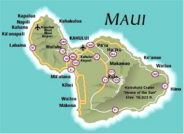
Here is a Maui map showing the main roads around the island.

This is a map of Maui`s other islands that make up Maui county
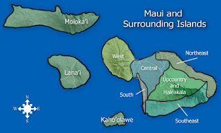
Here is a map of Maui`s different regions, each of which have their own climatic variations and different atmosphere.

I hope the Maui maps above were useful!
Maui is the second largest of the islands of Hawaii, with a land area of 727.2 square miles, or 1883 square kilometers. It is also the name of the county that includes the island itself, plus four other smaller islands named Lana`i, Kaho`olawe, and Molokai. The island has a population of 144,444, making it the third most populous (after O`ahu and Hawaii).
The climatic conditions on Maui are surprisingly varied, with different areas of the island having quite different amounts of clouds and rain fall, varying humidity levels, and different temperature ranges.
One popular activity for tourists on Maui is whale-watching, since Humpback whales come to the `Au`au Channel in winter. It is also know, of course, for its beautiful beaches and laid-back vacation atmosphere.
Here is a Maui map showing the main roads around the island.
This is a map of Maui`s other islands that make up Maui county

Here is a map of Maui`s different regions, each of which have their own climatic variations and different atmosphere.

I hope the Maui maps above were useful!


0 Comments