Please look down below for an East Germany map
East Germany, officially known as the German Democratic Republic or GDR, was a socialist country that arose in the areas of Germany occupied by the USSR after World War II. The state was declared in 1949.
Existing in the northeastern section of pre-WWII Germany, East Germany occpuied an area of 107,771 square km, or 41,610 square miles. It was bordered by Czechoslovakia to the south, West Germany in the south and west, Poland to the east, and the Baltic Sea to the north.
The German capital city of Berlin was located inside East Germany, but an Ally-occupied enclave existed in West Berlin, effectively cutting the city in two, with the Berlin Wall separating them. The Communist government was overthrown in the revolution of 1989, with the Berlin Wall being torn down seen by the world as a symbol of the triumph of democracy.
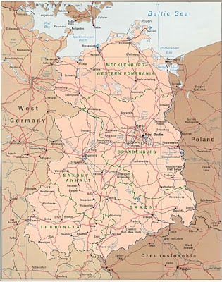
This first East Germany map is quite an old one showing all the roads and highways in the country.
Here is a map of West and East Germany that clearly indicates all the major cities and towns.

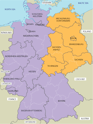
This West and East Germany map is simple and printable, showing the various administrative regions.
East Germany, officially known as the German Democratic Republic or GDR, was a socialist country that arose in the areas of Germany occupied by the USSR after World War II. The state was declared in 1949.
Existing in the northeastern section of pre-WWII Germany, East Germany occpuied an area of 107,771 square km, or 41,610 square miles. It was bordered by Czechoslovakia to the south, West Germany in the south and west, Poland to the east, and the Baltic Sea to the north.
The German capital city of Berlin was located inside East Germany, but an Ally-occupied enclave existed in West Berlin, effectively cutting the city in two, with the Berlin Wall separating them. The Communist government was overthrown in the revolution of 1989, with the Berlin Wall being torn down seen by the world as a symbol of the triumph of democracy.
This first East Germany map is quite an old one showing all the roads and highways in the country.

Here is a map of West and East Germany that clearly indicates all the major cities and towns.

This West and East Germany map is simple and printable, showing the various administrative regions.


.png)


0 Comments