A Palm Springs map for your travel reference can be found down below.
Palm Springs, California is a popular desert resort famous for its golf, swimming, tennis, horseback riding, and desert hiking. It is also a popular destination for retirees to relocate to, thanks in large part to the year-round warm climate.
Palm Springs is located inside the Coachella Valley, which is a desert valley surrounded by San Bernardino Mountains to the north, and the Santa Rosa Mountains to the south, the San Jacinto Mountains to the west, and the Little San Bernardino Mountains to the east. The summers are very hot and dry, and the winter months are warm with daily highs generally rising above 20 degrees - sometimes as high as 30. The winter can be cool at night, but normally pleasantly cool. Summer temperatures commonly reach the mid-40s with lows in the 20s or even 30s.
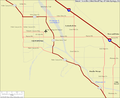
The first map here is a general one showing the main thoroughfare roads and highways, with the airport smack-dab in the middle. If you`re driving in from elsewhere in California then you may not need any more detail than this.
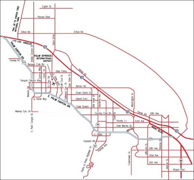
The next map here shows some more detail, primarily the smaller streets in between all the main roads. If you`re actually driving or walking around in the town, then you might need to know the city layout a bit more closely.
Hopefully the map of Palm Springs above were good and useful for you. I hope you enjoy your trip to this upscale resort!
Palm Springs, California is a popular desert resort famous for its golf, swimming, tennis, horseback riding, and desert hiking. It is also a popular destination for retirees to relocate to, thanks in large part to the year-round warm climate.
Palm Springs is located inside the Coachella Valley, which is a desert valley surrounded by San Bernardino Mountains to the north, and the Santa Rosa Mountains to the south, the San Jacinto Mountains to the west, and the Little San Bernardino Mountains to the east. The summers are very hot and dry, and the winter months are warm with daily highs generally rising above 20 degrees - sometimes as high as 30. The winter can be cool at night, but normally pleasantly cool. Summer temperatures commonly reach the mid-40s with lows in the 20s or even 30s.
The first map here is a general one showing the main thoroughfare roads and highways, with the airport smack-dab in the middle. If you`re driving in from elsewhere in California then you may not need any more detail than this.

The next map here shows some more detail, primarily the smaller streets in between all the main roads. If you`re actually driving or walking around in the town, then you might need to know the city layout a bit more closely.

Hopefully the map of Palm Springs above were good and useful for you. I hope you enjoy your trip to this upscale resort!


.png)

0 Comments