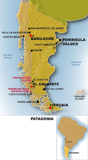
Below you can select a Patagonia map that you think will be helpful for your reference or travels. Patagonia is not a country but rather a geographic region consisting of the southermost part of the continent of South America. It lies within two countries, Argentina and Chile, though not all of those countries' territory lies within the region of Patagonia. This region features the southernmost portion of the Andes mountains in the west and south, and a plateaux and lowlands in the east. Its northern boundary is the Neuquen River and Colorado rivers.
The Argentine part of Patagonia consists of mostly steppe-like plains, which rise in a succession of terraces, each one about 100 meters higher than the one before it as we move towards the Andes. It is covered with mostly shingle and very little vegetation, but as we move towards the Andes vegetation and wildlife becomes more abundant.
Patagonia is a land of wondrously diverse and beautiful landscapes. I hope you get the chance to visit soon.


I hope you found a useful Patagonia map for your journeys!


.png)

1 Comments