Australia is a country located in Oceania, surrounded by the Pacific and Indian Oceans. It is simultaneously considered a country, a continent, and an island. The mainland of Australia is the largest island in the world. Australia does, however, contain more than 8,000 islands and is not a single island. This includes many small islands, but also Tasmania, which is an entire state located on an island south of the mainland.
Australia has 6 major climatic categories depending on elevation and other factors. Climates range from equatorial and tropical in the north, to temperate on the southern coast. In the middle there are vast ranges of desert and grasslands.
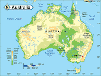
Below you can find an Australia physical map for your reference and research.
First is a climate and weather map Australia.


I hope you found an Australia physical map that was useful for your reference. Please check back again soon for more maps and destination profiles!
Australia has 6 major climatic categories depending on elevation and other factors. Climates range from equatorial and tropical in the north, to temperate on the southern coast. In the middle there are vast ranges of desert and grasslands.
Below you can find an Australia physical map for your reference and research.
First is a climate and weather map Australia.


I hope you found an Australia physical map that was useful for your reference. Please check back again soon for more maps and destination profiles!


0 Comments