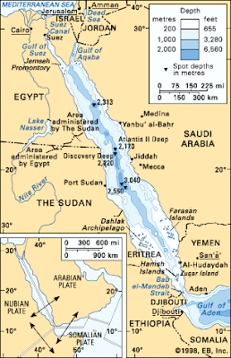
The Red sea is a narrow inlet of the Indian Ocean, that extends up between Africa and Asia. At its northern edge it borders the Sina Peninsula of Egypt, Israel, and Jordan at the subdivision called the Gulf of Aqaba. Further south it borders mainland Egypt, Saudi Arabia, Sudan, Eritrea, Yemen, and Djibouti.
The entire Red Sea has a surface area of 438,000 square km, or 169,100 square miles. It is 2250 km long from north to south, and is around 355 km wide at its widest point. Though at some points it is extremely narrow, for example in the Gulf of Aqaba. I have travelled through the Gulf of Aqaba by ship, and at some points it is only a kilometer or two wide, and if you look in one direction you see Saudi Arabia and if you look the other you see Egypt.
The sea life in the Red Sea is spectacular, with Eilat in Israel and Sharm el Sheikh in Egypt being two popular dive resorts and winter escapes for tourists from Europe. Dahab and Nuweiba in the Sinai Peninsula are also great places to snorkel and dive.
Here you may find a Red Sea map to help explain the geography of the area.

I hope the above Red Sea maps were useful. Have a look around at our categories and see all the other maps and destination profiles available.
The entire Red Sea has a surface area of 438,000 square km, or 169,100 square miles. It is 2250 km long from north to south, and is around 355 km wide at its widest point. Though at some points it is extremely narrow, for example in the Gulf of Aqaba. I have travelled through the Gulf of Aqaba by ship, and at some points it is only a kilometer or two wide, and if you look in one direction you see Saudi Arabia and if you look the other you see Egypt.
The sea life in the Red Sea is spectacular, with Eilat in Israel and Sharm el Sheikh in Egypt being two popular dive resorts and winter escapes for tourists from Europe. Dahab and Nuweiba in the Sinai Peninsula are also great places to snorkel and dive.
Here you may find a Red Sea map to help explain the geography of the area.


I hope the above Red Sea maps were useful. Have a look around at our categories and see all the other maps and destination profiles available.


.png)
0 Comments