The Republic of Philippines is a country located in Southeast Asia, in the western area of the Pacific Ocean. It lies just south of Taiwan, east of Vietnam, and northeast of Indonesia. It is an island nationarchipelago consisting of 7,107 islands and occupying 300,000 square km (116,000 square mi) of land area (including its territorial waters). Its total coastline stretches on for 36,289 km (22,549 mi)
making it one of the countries with the longest coastlines in the world.
There are three main regions of Philippines: Luzon, the Visayas, and Mindanao. The Luzon island group includes the island of Luzon itself (the seat of Manila, and one of the most important islands in Philippines) along with some nearby peripheral islands. The Visayas consists of a number of major islands including Cebu, Panay, Negros, Bohol, Leyte, and Samar. The Mindanao island group includes the island of Mindanau itself, the second largest island in the country, as well as nearby peripheral islands.
Below are some Philippines maps for your reference.


making it one of the countries with the longest coastlines in the world.
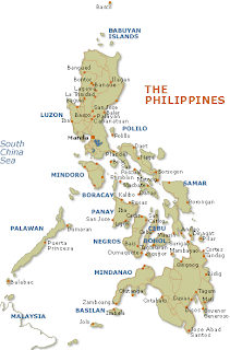
There are three main regions of Philippines: Luzon, the Visayas, and Mindanao. The Luzon island group includes the island of Luzon itself (the seat of Manila, and one of the most important islands in Philippines) along with some nearby peripheral islands. The Visayas consists of a number of major islands including Cebu, Panay, Negros, Bohol, Leyte, and Samar. The Mindanao island group includes the island of Mindanau itself, the second largest island in the country, as well as nearby peripheral islands.
Below are some Philippines maps for your reference.


.png)

0 Comments