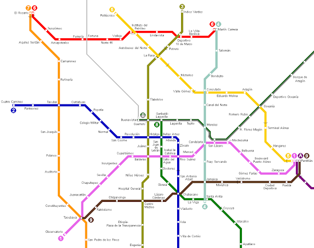
Mexico City is a massive city, one of the largest on Earth, which means that it needs good transportation -- preferably mass rapid transit. And it has exactly that - a metro rail and subway system called the STC ("Sistema de Transporte Colectivo" in Spanish - which literally means public transportation system). It is a large system with 195 stations on 12 lines stretching on for a total of 226.49 km. 115 of the stations are underground, yet it is not entirely a subway system.
Riding the metro is cheap, costing $5 Mexican (pesos), which is roughly 35 cents US - for a ticket that gives you unlimited travel distance for any one ride. You can travel just one station away, or you can cross the whole town and the price doesn`t increase (on most lines, anyway).
It is one of the busiest metro systems in the world, with around 1.7 billion passengers riding it per year.
Here are some maps of the Mexico City metro system (the STC):
The STC was created for the average person and is incredibly cheap, easy-to-use, and convenient as a result. Taxis aren`t expensive by international standards either, but if you`re staying for a while then you might want to reduce your transportation costs and have an interesting Mexico experience by riding the metro. I hope these maps are helpful!
LIKE, SHARE, or TWEET this page if you found it helpful! :) Thanks!


.png)
0 Comments