Metro Manila is a massive metrolpolis consisting of Manila City, the national capital; Quezon City, the nation's most populous city and former capital; and 14 other cities and municipalities. Metro Manila has a population of over 11 million. If the nearby suburbs in neighbouring provinces are included, then the greater Metro Manila conurbation has around 22 million people.
This extensive sprawl is well connected by its road network, but traffic in Manila is still horrendous. There are just so many people driving, and there aren`t enough expressways, and there aren`t enough MTR and LTR stations to clear up some of the streets. The middle of the day isn`t too bad, but rush hour is a nightmare.
Compared to a city of a similar size like Tokyo, Manila`s roads are FAR more crowded and chaotic.
First for perspective, here's a simple printable map of Metro Manila with no roads shown.
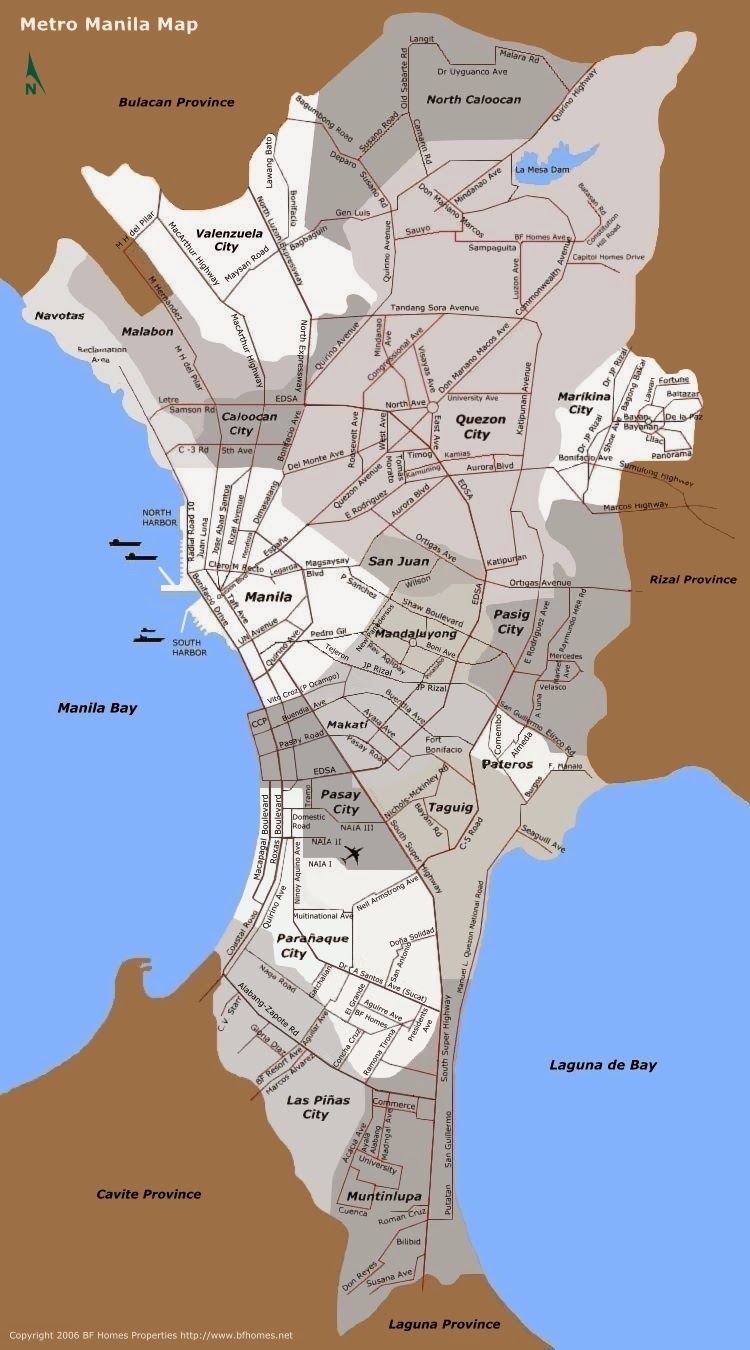
Here's a road map of Metro Manila, or the National Capital Region (NCR) as it's also known. These are the main roads traversing the metro area.
Metro Manila is so incredibly huge and densely populated that it`s difficult to show you more detail than the above on a single map. But here are three maps each showing part of the metro, and together giving you the overall picture.
First is Northern Metro Manila, including Quezon City which has the largest population out of all cities in the metro. Click on the maps to see them bigger, and then right click and download them to see them in all their full-size glory! :)
And here is the map of southeastern Metro Manila, including Taguig and Markinia.
A detailed street map of Manila City itself.
I hope these maps of Manila are useful. I love Philippines, so there will more maps from the Philippines very soon.
LIKE, SHARE, or TWEET this page if you found it useful! :) Thanks!
This extensive sprawl is well connected by its road network, but traffic in Manila is still horrendous. There are just so many people driving, and there aren`t enough expressways, and there aren`t enough MTR and LTR stations to clear up some of the streets. The middle of the day isn`t too bad, but rush hour is a nightmare.
Compared to a city of a similar size like Tokyo, Manila`s roads are FAR more crowded and chaotic.
First for perspective, here's a simple printable map of Metro Manila with no roads shown.
Here's a road map of Metro Manila, or the National Capital Region (NCR) as it's also known. These are the main roads traversing the metro area.
Metro Manila is so incredibly huge and densely populated that it`s difficult to show you more detail than the above on a single map. But here are three maps each showing part of the metro, and together giving you the overall picture.
First is Northern Metro Manila, including Quezon City which has the largest population out of all cities in the metro. Click on the maps to see them bigger, and then right click and download them to see them in all their full-size glory! :)
Next is south central Metro Manila, including Makati - the district where most expats and a lot of middle-to-upper class Filipinos live.
A detailed street map of Manila City itself.
I hope these maps of Manila are useful. I love Philippines, so there will more maps from the Philippines very soon.
LIKE, SHARE, or TWEET this page if you found it useful! :) Thanks!


.png)
1 Comments