Brazil is the largest country in South America and fifth largest country in the world. In fact, it occupies nearly half of the continent of South America, in total 8,514,877 km2 (3,287,597 sq miles). It borders Uruguay to the south, Argentina and Paraguay to the southwest, Bolivia and Peru to the west, Columbia to the northwest, and to the north lie Venezuela, Suriname, Guyana, and French Guiana.
It is so large that it spans three time zones. Its landscapes include mountain ranges, plains, highlands, hills, and scrublands. Our image of Brazil usually consists of Rio di Janeiro's beaches and the Amazon Basin, but in fact much of Brazil lies at 200-800 meters above sea level. Some areas of Brazil have an equatorial climate, others a highland tropical climate, others a temperate climate with coniferous forests, semiarad desert climates (in the northeast).
The largest city in Brazil is Sao Paulo with an impressive 11,150,249 people. Rio de Janeiro is second with 7,145,472 people.
There are 26 states plus one federal district of Brazil.
Below you can choose a physical map of Brazil. Click on the maps to make them bigger.


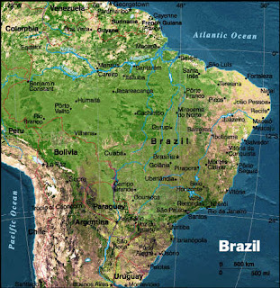

In addition to the above physical maps here is a political map of Brazil as well.

I hope that up above you were able to find a good map of Brazil South America!
LIKE, SHARE, or TWEET this age if you found it useful. That`s a big help to us. :) Thanks!
It is so large that it spans three time zones. Its landscapes include mountain ranges, plains, highlands, hills, and scrublands. Our image of Brazil usually consists of Rio di Janeiro's beaches and the Amazon Basin, but in fact much of Brazil lies at 200-800 meters above sea level. Some areas of Brazil have an equatorial climate, others a highland tropical climate, others a temperate climate with coniferous forests, semiarad desert climates (in the northeast).
The largest city in Brazil is Sao Paulo with an impressive 11,150,249 people. Rio de Janeiro is second with 7,145,472 people.
There are 26 states plus one federal district of Brazil.
Below you can choose a physical map of Brazil. Click on the maps to make them bigger.


In addition to the above physical maps here is a political map of Brazil as well.

I hope that up above you were able to find a good map of Brazil South America!
LIKE, SHARE, or TWEET this age if you found it useful. That`s a big help to us. :) Thanks!


.png)
0 Comments