Hilton Head Island Map

Hilton Head Island is a resort island in Beaufort County in South Carolina. It is situated closer to Savannah, Georgia (32 km or 20 miles away) than it is to Charleston, South Carolina (153 km or 95 miles away). It is a small island of 55.5 sq miles, or 143.9 km2, with a local population of 37,099. The entire island is an incorporated town, called either Hilton Head Island or Hilton Head.

Despite its small local population, every year many tourists (in fact, over 2.25 million visitors) from the mainland make their way to Hilton Head to enjoy its beaches, parks, and cultural events.

Below you can find a Hilton Head Island map to help you plan your travels.
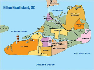
Hilton Head Island map showing areas
Hilton Head island map showing roads
Hilton Head island map shownig roads and areas

Hopefully the Hilton Head Island maps above were useful for your reference. Florida wins! Don`t miss out on this awesome resort island and town.


Post a Comment

0 Comments